![]() CHARLES FAIR
CHARLES FAIR
![]()
The St. Gond marshes lie between Epernay and Sezanne and are formed by the headwaters of the Petit Morin. This area was critical during the 1914 Battle of the Marne as the Germans hoped to break the French line in this area so that they could round up the French and BEF forces to the west. Of course, at this time the Germans were also defending against the French counter-attacks during the Battle of the Ourcq. Foch, the commander of the French 9th Army started to build his reputation at St. Gond for his army's brave defence and subsequent counter-attack.
The main objective of our expedition was to follow a circuit around this area which is described in the Michelin Guide 'The Marne 1914'. In particular I was hoping to take present day versions of several of the photos in the guide. The area overlaps with three of the IGN 1:100,000 green series maps: 9 - Paris-Laon, 10 Reims-Verdun and 22 Troyes-St Dizier. We were staying with friends who live east of Chateau Thierry, so were able to approach the St. Gond area from the north. This enabled us to make a couple of brief stops en route to the area covered by the Michelin Guide.
We first halted at St. Agnan (5 miles SW of Dormans) which marks the furthest limit of the German advance on 18 July 1918 in this sector. By the road which descends the side of the valley to the north of the village is a board with a panoramic painting. This describes the fighting around the village during the battle. 'American Armies and Battlefields in Europe' explains (p. 65) that the US 28th Division was engaged in defensive operations in the Bois de Rougis which can be seen on the hillside south of the village.
About 2 miles west of Montmirail on the D373 is a monumental column that commemorates Napoleon's victory at the Battle of Montmirail in 1814. On the other side of the road is a small monument to the St-Cyriens of the Montmirail promotion. This is engraved with a sword and dedicated "A la glorieuse mémoire des 233 Saint-Cyriens de la promotion de Montmirail 1912-1914, morts pour la France entre 1914 et 1918". This monument was inaugurated by General Hallier. The Roll of Honour for St. Cyr that I had acquired in Brittany (see Brittany part 2) shows that each promotion, or class, from the academy is typically named after a battle or a famous soldier. The Montmirail promotion comprised 463 cadets, of whom 241 (52.1 per cent) died "pour la patrie" in all wars. This is the third highest death rate of all the classes. The 233 Great War casualties are mainly from 1914 and 1915. This is shown by the ranks of all 241 casualties: 216 were sous-lieutenants or lieutenants; only 19 reached the rank of captain, and only 6 reached a higher rank.
On the D47 at the eastern edge of the village of Charleville (7 miles SE of Montmirail) is a monument to the 2nd R.I. This monument is marked on the 1:25,000 IGN map 27140 Orbais-l'Abbaye. It recalls that the regiment lost 800 men and Colonel Perez, its Commanding Officer, on 6 September 1914. The Michelin Guide states that Charleville "which had been taken on the 6th by the 20th Division, remained in possession of the French. The fighting was extremely fierce all round the village, and particularly on the spot where the 2nd Infantry Regiment distinguished itself."
At Broyes (3 miles NE of Sezanne) we started the Michelin Guide itinerary. The entrance to the Chateau des Pucelles looks exactly as it does in the Guide. This is where General Humbert, the GOC of the Moroccan Division, established his headquarters on 7 September 1914. The village is perched on the edge of the plateau and overlooks the Aube plain.
From Broyes we drove eastwards along the D39, following the edge of the plateau to Allemant. Another 300 yards or so east on the D39 is a pretty view of Allemant, the Aube plain and the escarpment. This view doesn't appear to have changed in 80 years since it exactly matches the panorama shown on pp 160-161 of the Michelin Guide.
From Allemant we took a detour from the itinerary and headed south-east across the Aube plain to Pleurs. The mairie was Foch's HQ from 5-8 September 1914 and a plaque records this fact. Foch had to move his HQ at short notice as the Germans reached the nearby village of Connantre on the morning of the 9th.
The D205 between Linthes and Pleurs crosses the ground where General Grossetti's 42nd Division counterattacked elements of the German 12th Corps. Having taken Connantre, the Germans were threatening to break through the centre of Foch's line. Foch ordered the 42nd Division, his reserve, which had just suffered four days of bitter fighting, to attack the Germans head-on. This it did at about 4pm, and its unexpected appearance demoralised the German troops. According to the Michelin Guide: "the German generals had at that time nothing with which to counter this last effort of Foch's, and, realising that the battle was indeed lost, began to make preparations for retreat".
We then drove on to Connantre itself. Here there is a German cemetery which contains 8,930 graves, of which over 6,000 or so are in two large ossuaries. These men are commemorated with two walls, each about 20 feet long, on which their names are inscribed. We noticed the grave of a Lt Werner Graf von Moltke, who was killed on 6 September, and wondered if he was a relative of the generals of the same name. There is also a monument which has a bas-relief of the "Deposition de croix" which is made out of fired clay. This German cemetery must be the most southerly in the Marne region.
From Connantre we drove north to Mont Aout where we had a picnic. This hill dominates the southern flank of the marshes as well as the Aube plain to the south. It was captured by the Germans on the morning of the 9th September after a fierce struggle, but was recaptured by the French on the 10th as the Germans had abandoned it when they began their retreat. The hill itself and the escarpment reminded me strongly of the Chiltern Hills near Ivinghoe Beacon in Hertfordshire and Bedfordshire, or the hillsides on the edge of Salisbury Plain. The Champagne vineyards were the only obvious reminder that we were in another country. The area is, for me, one of the prettiest sectors of the Western Front.
We then crossed the marshes by one of the causeways. The Germans eventually succeeded in crossing the causeways on the 8th September, after several days of stiff resistance by the French. We drove along the northern edge of the marshes to reach St. Prix where the Petit Morin flows out of the western end. This was the scene of bitter fighting as the two armies struggled for control of this point. There is a fine 12th Century Church and I was able to take several "then and now" photos which show that this area has changed little since 1919.
Near the cross-roads in Soizy aux Bois is a small and rather scruffy French cemetery. This contains 1,692 men in two ossuaries. Heading east on the D44, after about 2.5km and just before the road forks to the west of Oyes, a small track on the left leads through a cutting to the top of the ridge that lies on the north of the road. Here there is a viewpoint that is described in the Michelin Guide that gives a 360 degree panorama of the marshes and surrounding hillsides. (It is marked on the 1:25,000 IGN map 27140 Orbais-l'Abbaye with a spot height of 174 metres.) We were able to get an exact match with the views shown in the Guide.
We drove on through Oyes to the priory of St. Gond which lies to the north-west of the village. This settlement was set up by St. Gond, a hermit monk who came to live in this secluded place in the seventh century. The priory had fallen into ruins before 1914, and the Michelin Guide shows a picture of the gatehouse. We were surprised to find that the gatehouse and entrance buildings had been renovated in 1985 and now appear to be a very comfortable residence.
Finally we reached Mondemont, the highlight of the day. This village was the pivot of the battle on 9 September 1914: the French needed to hold the village in order to deny the ridge to the Germans. The bombardment of the castle began on the morning of 7 September, and the Germans succeeded in taking it on the morning of the 9th. The 77th Regiment d'Infanterie were ordered to counter attack from the south side, with support from the Zouaves who were to attack the western side.
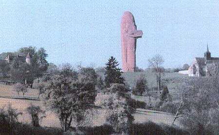
With the chateu to the left and the church to the right, this is roughly
the view seen by the Germans when they took the chateau on the morning of
9th September, 1914. (Photo: "Association Mondement 1914.")
According to the Michelin Guide, "the attack began at 2.30 pm. Major de Beaufort's battalion, composed of Bretons, to whom one of their comrades had just given absolution, left the woods, their bugles sounding the charge. A murderous fire met them from the castle, but could not stop them. A breach had been made in the wall be one of the French 75s, and towards this Major de Beaufort rushed, only to be struck by a ball in the forehead."
However, German machine-gun and rifle fire prevented them from getting through the breach. "An entry in mass, which alone could have ensured success, was impossible. ... At the end of an hour of costly efforts, orders were given to fall back, and the troops retired into the woods."
"Pieces of artillery were then dragged to within three or four hundred yards of the castle. The breaches in the wall increased, the railing collapsed in parts and the interior of the castle became untenable. When the French renewed the attack at nightfall, they no longer met with resistance, for the garrison had fallen back on the marshes. The retreat had become general on the front of Von Hausen's and Von Bulow's armies."
The main building, north wing, and front gates of the chateau appear to be unchanged from the Guide, except that the battle damage is now repaired. The front wall of the chateau has a bas-relief of General Humbert, the G.O.C. of the Moroccan Division. However, the southern wing was not rebuilt since it was destroyed by the French 75s at close range.
The church also looks exactly as it does in the Guide. The wall of the churchyard has several plaques to the defenders and a grave with about 10 burials. One of the plaques recalls the commemoration on the 50th anniversary of the battle when the 77th R.I. and the 4th Hanoverian Infantry Regiment (No. 164) "reunited in remembering their glorious dead and their brave comrades". Mondement Farm has also been repaired, although the gate has been removed to allow modern farm machinery to enter.
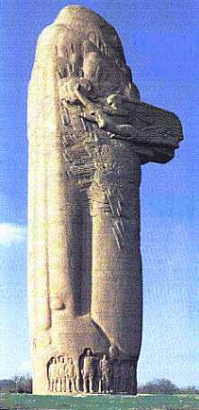 |
However, the one thing that the visitor cannot fail to miss is the 33 metre high Monument to the First Battle of the Marne. It is made of 2,000 tonnes of reinforced pink concrete and is of a style that can only be described as "unique". It was designed by the architect Bigot and sculpted by Bouchard and deliberately resembles a Breton menhir. Whether one likes it or loathes it, the visitor will not fail to be impressed. Joffre's famous order of the day of 6 September 1914 is inscribed on the north face, and the order of battle of the armies is inscribed on the south face. At the foot of the north face is a bas-relief sculpture of the army commanders. In the middle are an outsized Joffre and a poilu. On their right (east) are lifesize impressions of Generals Sarrail (3rd Army), de Langle de Cary (4th), and Foch (9th). On their left (west) are Franchet d'Esperey (5th), Sir John French (BEF), Manoury (6th) and Gallieni (Army of Paris). The monument along with the church and chateau make Mondement, in my opinion, an outstanding Great War site. |
The Memorial at Mondement |
After leaving Mondement we turned back towards Paris, passing via Sezanne and Esternay. Our final visit of the day was to Courgivaux, which is about 4 miles west of Esternay. This is one village in which the Germans chose to make a stand soon after they had begun their retreat in September 1914. At 1600 hrs on 6 September the Germans opened fire on the French troops who were advancing across the open fields. The French 5th Division assaulted the village which changed hands five times on 6-7 September 1914. Total casualties (killed wounded and missing) were 22 officers and 1,590 men. (See Between Mutiny and Disobedience: the case of the French 5th Infantry Division in World War I by Leonard V. Smith pub 1994, Princeton University Press.) Adjoining the communal cemetery on the south side of the village is a French Military Cemetery which contains 224 dead. Of these, 193 are buried in an ossuary and there are several individual graves of men of the 39th and 129th Regiments of the Division. On the wall is a plaque dedicated to the memory of a Captain Vaillant who was killed during this action. The adjacent fields are those over which the French attacked.
![]()
 Copyright © Charles Fair, May,
1997.
Copyright © Charles Fair, May,
1997.
Return to the Charles Fair Battlefield Guide START page
Return to the Hellfire Corner Contents Section
|