![]() CHARLES FAIR
CHARLES FAIR
![]()
The Southern Vosges
This area is covered by the IGN 1:100,000 green series map 31 'St. Die - Mulhouse - Basle'. Several maps of the 1:25,000 Top 25 series cover the area in more detail.
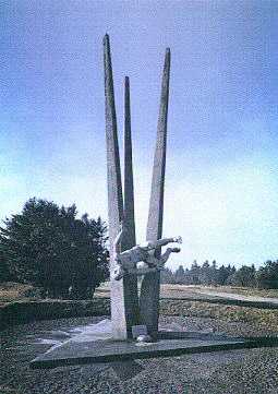 |
Our first stop in the Vosges was at the Ballon d'Alsace, the southernmost of the major Vosges peaks. The summit was exactly on the pre-war Franco-German border and was the first major peak occupied by the French in August 1914. It is due north of Belfort on the D465. By the car park at the summit of the road, which doesn't quite go over the top of the mountain, is the Monument aux Demineurs. This modern monument commemorates those who died while clearing mines and other ordnance from battlefields in France. It thus appears to include civilians and former soldiers, as well as serving soldiers, in both peace and wartime. The monument symbolises an explosion with a fan of three thirty-foot-long concrete spikes forming the backdrop to a naked man who has been thrown into the air by the mine beneath him. The rather tacky souvenir shop nearby contains a minuscule museum which consists of numerous examples of mainly WW1 era shells and other mementoes to do with mine clearance. |
We then dropped down the eastern side of the mountain on the hairpin bends on the D466 to Masevaux. Some of the bridges on this road were built by the French Army and they carry the words "7eme Armee 1917".
We based ourselves on the southern edge of the Vosges in the small town of Thann which must be one of the prettiest towns on the Western Front. The town itself highlights the ambiguous nature of Alsace, or Elsass, with a style of architecture (and beer) that is unmistakably Germanic, yet many small things such as signs, and shops that are equally unmistakably French.
Thann was taken by the French on 7 August 1914, but was lost to the Germans a few days later, and was not retaken until December. On the Hotel de Ville is a plaque to the 133 R.I. which entered the town on 7 August "after 44 years of German annexation and to those of its soldiers who fell in the fighting of 9 and 10 August 1914". A few yards away is the Monument to the 66th Division of Chasseurs - an Alsatian unit - which features a bas relief of its last commander General Brissard-Desmoulet. In front of this is a bronze plaque which displays a quotation from the speech given by Joffre in the mairie on 24 November 1918: "Je suis la France, vous êtes l'Alsace; je vous apporte le baiser de la France". (I stand for France, you are Alsace; I bring you the kiss of France.)
The next morning we drove four miles east to Cernay. Here there is a French military cemetery which contains 2,238 French Great War casualties, of which 938 are in two ossuaries. Unusually there are also 45 Czech Great War casualties who are commemorated by two Monuments aux Morts Tchecoslovaques. Unusually for a French military cemetery, this one is full of floral colour, with a red rose beside every cross. This is in keeping with the region, since the Alsatian people must be the keenest gardeners in France.
From Cernay we drove up the Route des Cretes, a road built by French military engineers, to the most famous site in this sector of the front: the Hartmannswillerkopf. This mountain peak, at over 3,100 feet (956 m), gives one of the most commanding views in this region of France. It overlooks the Alsace plain, and the Rhine and the mountain ranges of the Hartz and Black Forest can be seen in the distance across the border. The Jura mountains can be seen to the south, and apparently the Swiss Alps on a clear day. For this reason, the mountain was the scene of several battles in late 1914 and 1915. If the French controlled the peak they were able to shell the Germans in the plain below. The Germans obviously tried to throw the French off the summit. The peak changed hands several times in 1915 before both sides settled down into a "live and let live" routine by sharing the summit. Some 60,000 soldiers of both sides are reputed to have lost their lives in the fighting for the mountain. (There are several interesting articles on the Hartmannswillerkopf in issue no. 25 of A.J. Peacock's journal "Gun Fire".)
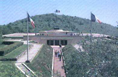
The Hartmannswillerkopf National Monument
"30,000 French and German fell on these hills."
Beside the Route des Cretes is the National Monument of the Hartmannswillerkopf which was inaugurated on 9 October 1932 by President Lebrun. It consists of a crypt which was excavated out of the bedrock. The entrance is approached by a cutting from the road and is flanked by two bronze representations of victory by the sculptor Bourdelle. Inside the crypt and covered by a large bronze shield is an ossuary which contains the remains of 12,000 unidentified soldiers. There are also Protestant and Jewish altars and a Catholic chapel with a Virgin by Bourdelle. On the esplanade which is situated above the crypt is the Altar de la Patrie. This symbolises the raising of volunteers en masse for the defence of France and the Republic. It bears on its sides the names of the cities which contributed to the building of the memorial.
On top of the bank near the entrance is a small Memorial to Lieutenant Pierre Scheurer who was killed nearby on 28 April 1915. Behind the crypt is a French military cemetery which contains 1,640 soldiers, of which 384 are in six ossuaries.
From the cemetery it is a walk of 500 yards or so to the summit of the mountain. Here there is a huge cross which can be seen from the plains below. Nearby there is a badly damaged 1918 marker stone. All around the summit are extensive French and German trench systems which have been uncovered and repaired over the last 30 years by the Amis de Hartmannswillerkopf. The trenches and numerous bunkers are in a remarkable state of preservation since they were dug out of the rock, with the stone being used to create parapets. Tons of concrete was hauled up the mountain by both armies and used to form bunkers and other fortified positions. The German positions generally seem to have made better use of reinforced concrete and there are several mutually supporting "festungs". The front lines are very close together and are within 20 yards - grenade-throwing range - in several places. At one of the narrowest parts of no-man's land is a Monument to the 28th battalion Chasseurs Alpins. A few yards away is a plaque which recalls that: "Three times in 1915 the 152 R.I. attacked and conquered this mountain at the cost of enormous sacrifice. On the 23 March the 6th Company made a particularly valorous assault which was cited in the Order of the Army and for which its Standard was decorated with the Croix de Guerre."
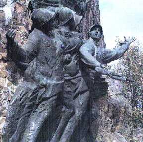
| Further along the summit ridge, 250 yards or so east of the cross,
is the impressive Monument to the "Diables Bleus" (Blue Devils) -
as the 152 R.I. were known. This is a bronze of five larger-than-life-size
poilus who are in heroic attacking poses. The sculpture is mounted on a sheer
rock face so that the figures can look out over the Alsace plain.
By following the path in the same direction down the spur I came to the Monument to the Bavarian Jagers which was restored in 1959. This consists of a pyramid of stones, into which are set a large number of plaques commemorating individual men. |
 |
For me, the site is one of the most impressive that I have so far seen on the entire Western Front. I wish I could have had more time to explore. The map of the site in "Gun Fire" no 25 shows that there are many underground rooms and tunnels with generators, winding gear for bringing material up the mountain, and so on. I am sure that a guided tour by someone who knows the site would be a fascinating experience.
Before going back to Thann, from the Hartmannswillerkopf we drove northwards along the Route des Cretes to the Col Amic. Here, beside the road, there is a small private Monument to Paul Amic, a French officer who was killed here in 1915.
![]()
 Copyright © Charles Fair, July,
1997.
Copyright © Charles Fair, July,
1997.
Return to the Charles Fair Battlefield Guide START page
Return to the Hellfire Corner Contents Section
|